This is an introduction into the geology near the Minor Manor cabin located along Wahatoya Creek just north of the East and West Spanish Peak. The focus is on Lover’s Leap and the large dike (vertical wall like rock layer) located a short distance up the canyon from the cabin. The motivation was to introduce a small boulder collected at the large dike so that is could be displayed at the Pueblo Community College near Canon City. Secondly it might be nice for people who visit Wahatoya Canyon.
Setting
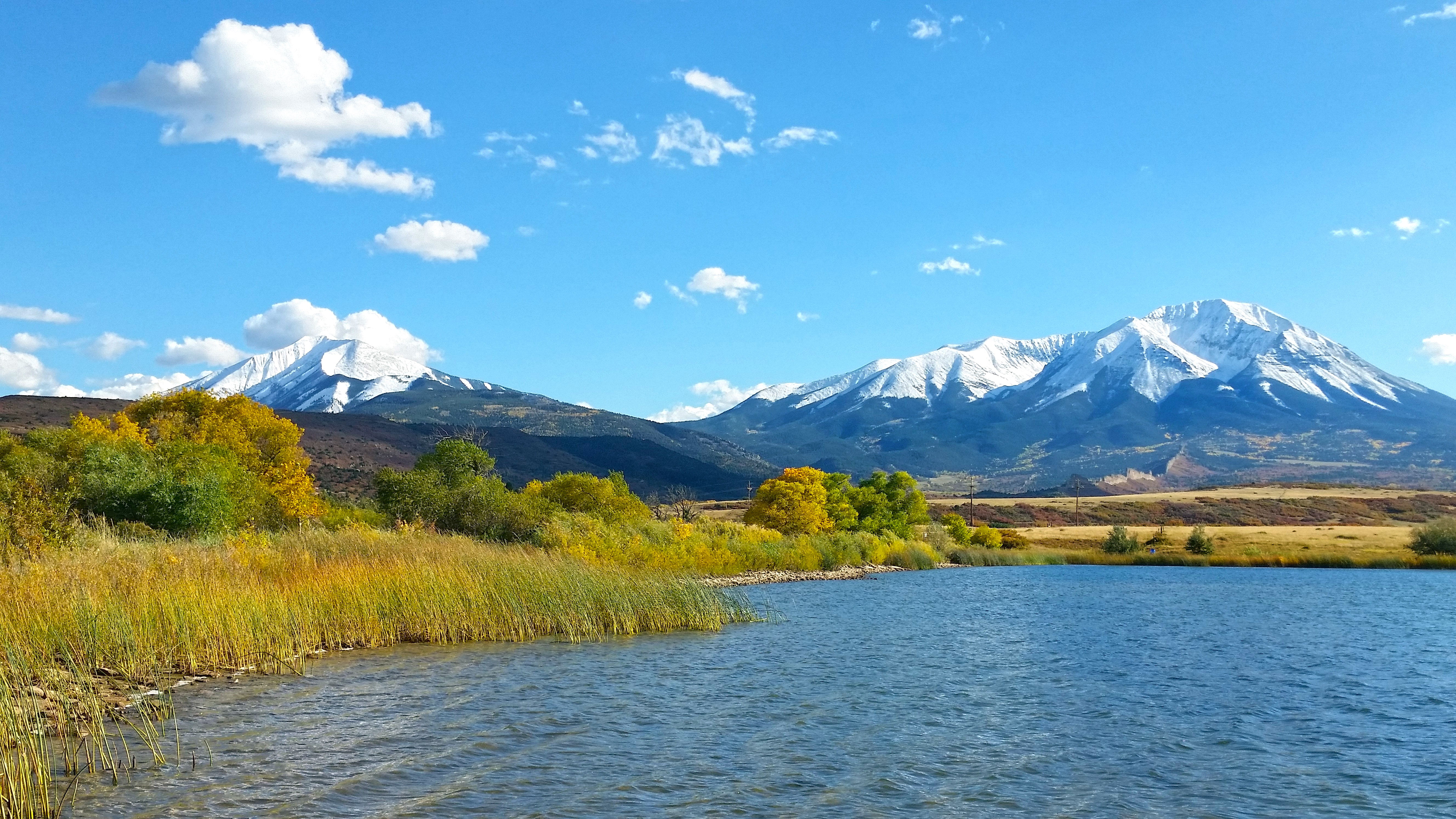
The Spanish Peaks prominently tower above the surrounding landscape along the front range of southern Colorado. The West Peak above towers about 7,500 feet and the East Peak about 6,500 feet above the plains.
JoAnn Grenard (Minor) has been traveling here since she was a baby. Her parents Henry and Jo had purchased a cabin in 1961 along what is called Wahatoya Creek (Little Kansas), draining the saddle area on the north side between the Peaks. Below are the two peaks as viewed from the La Veta lakes just above the community of La Veta.
JoAnn’s parents passed away some time ago but the four offspring (Dave, Janet, Gary, JoAnn) along with nine grandchildren and four great grandchildren have held onto the the Minor Manor cabin for now and probably well into the future. JoAnn and I now travel up there usually two or three times a year. The drive to the cabin officially begins in La Veta where everyone stops to buy an ice cream cone at Charlies grocery store. We usually stop at the town cemetery to visit the grave-sites of Grandpa Henry, Grandma Jo, and Uncle Pat and then drive south past the city lakes where the picture above was taken. We make a left and cross a beautiful meadow, then a right continuing pretty much due south along a beautiful mountain valley flanked on the west by the Wall Dike below.
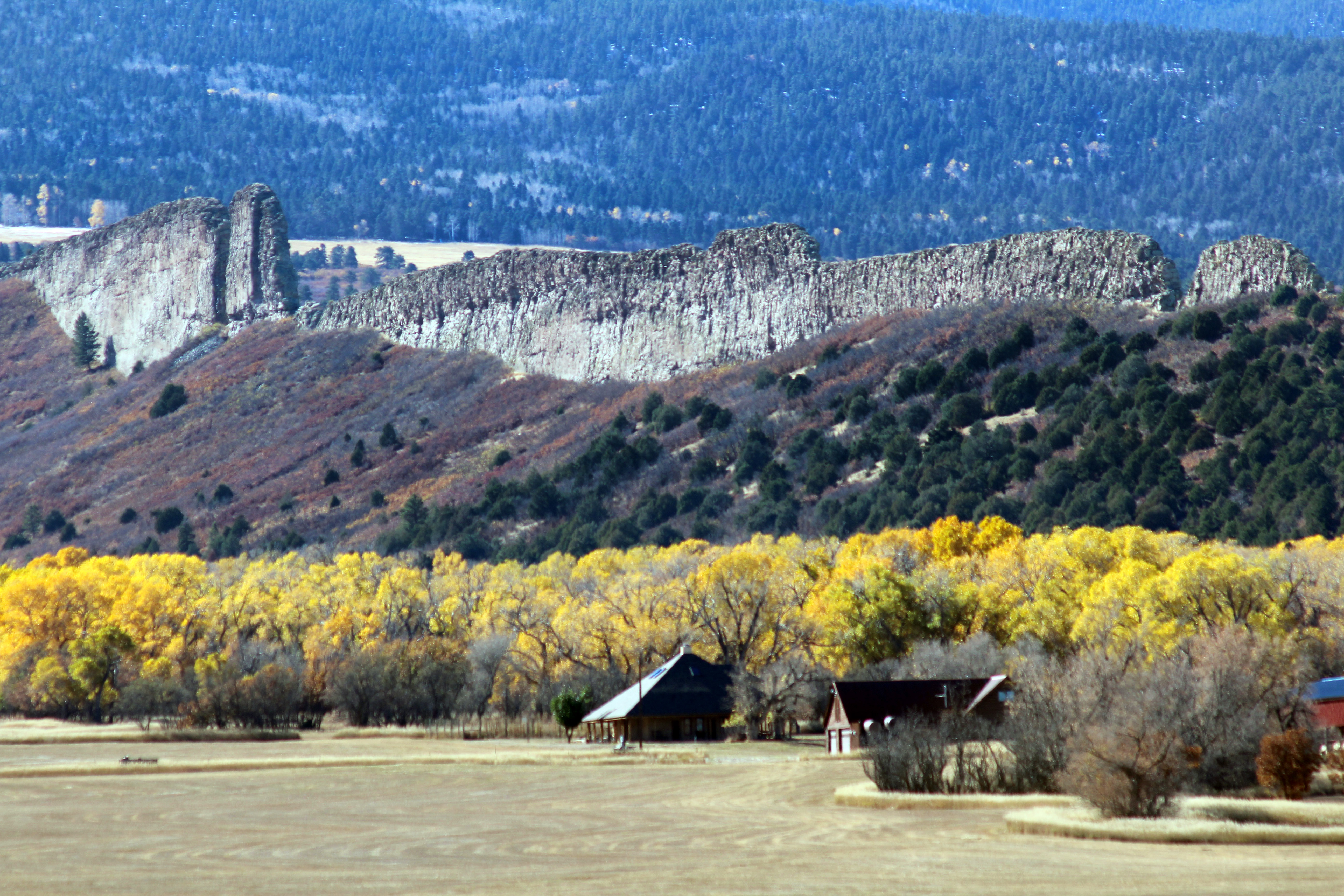
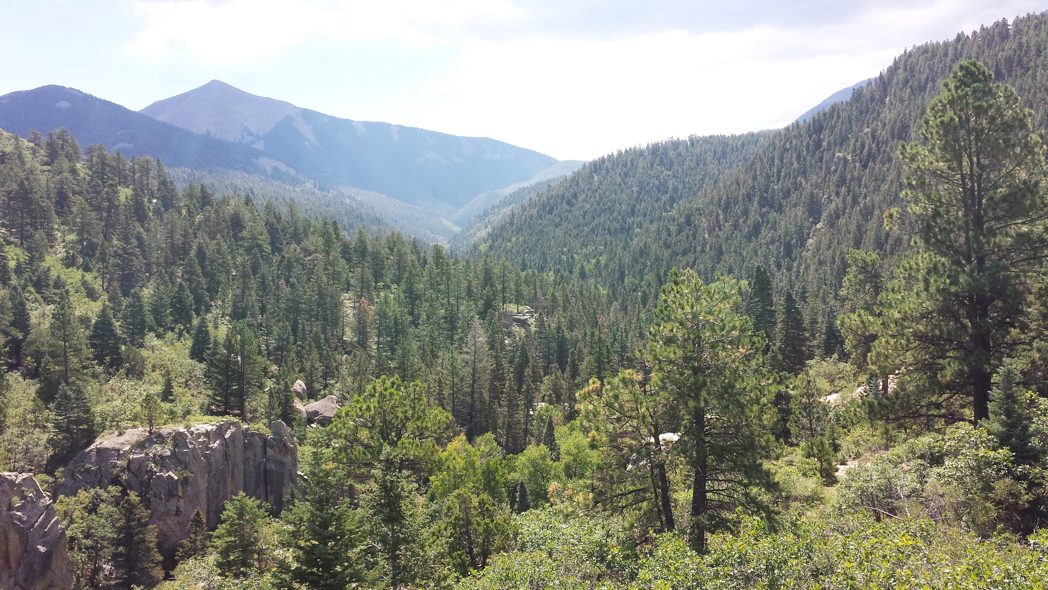
It’s not only the peaks, but the great walls or dikes like this one that radiate away from the West Spanish Peak that make the area special. Continuing south and gaining elevation, the road takes a left near the head of the valley up a hill where you crest at a gathering place commonly called “lovers leap” gaining a view into the headwaters of Wahatoya Creek shown below. There are maybe 50 cabins casually strung out along the creek, sometimes called “little Kansas” named for the large number of cabin owners from Kansas.
Other than the cabins along the creek and the bull’s eye mine four-wheel drive road on the northwest trending ridge above, everything in this area is part of the Spanish Peaks Wilderness managed by the US Forest Service. The string of cabins and the four-wheel drive road were grandfathered into the wilderness legislation.
++++++
Magma (A hot tempered dog’s name?)
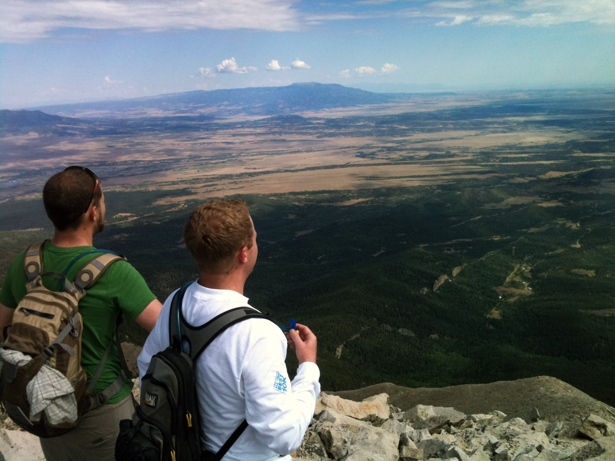
The Spanish Peaks region has an interesting look to it with a number of individual peaks off to the east of the Sangre de Cristo Mountain Range and south of the Wet Mountains. The East and West Spanish Peaks are the most well-known landmarks. Like Pikes and Longs Peaks you can see them from a long way away.
The best stepping off point to understand the peaks and the dikes (that I know about) is from the book “Geology Underfoot along Colorado’s Front Range” by Lon Abbott and Terri Cook available both in print and kindle versions. This excellent reference features a section on the Spanish Peaks. I’m including a few of their excellent drawings in this write up to help visualize the story behind the peaks. [1]
[1] Abbott and Cook, Geology Underfoot along Colorado’s Front Range.
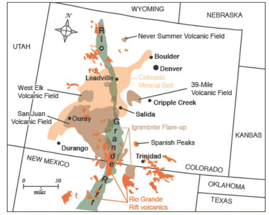
In the last 65 million years, the Rocky Mountains in the Colorado region has experienced three major volcanic periods. They are shown in tan, brown, and orange above and explained briefly below. The green area is representative of a rift zone (spreading plates) that is directly related to associated volcanic activity shown in orange.
Magma was intruded into tan colored areas shown from around Boulder trending southwest toward the San Juan Mountains between 65 to 45 million years ago. Colorado derived a significant part of its mineral wealth as a result of these intrusions.
Massive outpourings of silica-rich lava raged in a broad area shown in brown from 37 to 24 million years ago. The San Juan Mountains in southwest Colorado nicely reflect this amazing moment in Earth’s history, geologically referred to as the “ignimbrite flare up”. An ignimbrite represents hot suspension of pumice, ash, and gases flowing rapidly from a volcano, somewhat like Mt. Saint Helens, but in this time period the volcanic activity was particularly intense at times.
The third volcanic period is the one critical to our story. It began about 25 million years ago and is shown in orange. The crust of the Earth stretched apart along a north south rift zone in Colorado shown in green providing opportunities for magma deep in the earth to intrude into overlying layers.. The San Luis Valley reflects this rifting. The East Africa rift zone is a modern day example of this type of geology.
The Spanish Peaks magma stocks intruded into overlying sedimentary rocks (think long stringers in a lava lamp). The top of these pods or stocks never surfaced remaining several thousand feet below the surface at the time. These intrusions were so hot that they baked the sedimentary rocks around them for a few hundred feet. Today, the tops of these magma pods are exposed today at the summit of each peak but they are not alone; the hard-resistant baked sedimentary rock is there too. On our trip to the cabin you can see some of core stock material of the East Peak intrusion near the cabin Lover’s Leap which we touch on shortly.
It wasn’t just the stocks (magma pods) that intruded; they were followed by the intrusions of hundreds of dikes (vertical sheets of magma) into cracks of the surrounding sedimentary rock. These are evident today as one of the world’s great displays of rock walls that point toward the center of the West Peak, something you can observe as you drive along the road between La Veta and Cuchara. Interestingly these radial dikes don’t actually connect directly with the center core (stock) of the mountain. That is because they arrived later in time.
There are actually three general types of dikes surrounding the Spanish Peaks. The most common are the 500 or so dikes that radiate away from the West Spanish Peak. They range in width from less than a foot to over 100 feet and some dikes run for miles across the landscape. All of the radial dikes have a uniform composition but two adjacent dikes often have very different compositions indicating they were injected at different times. There is a much smaller second group of dikes trending east west and a third somewhat independent group.
Dikes are not uncommon but radial dikes around a core feature in such a major way as here at the West Spanish Peak is world class. There was just enough stress to create radial cracks in the overlying sedimentary rocks that were intruded by upward movement of magma. A good visualization trick is cup one hand and push up one finger into your palm so your fingers spread. The spreading at the time were radial cracks that enabled hot magma fluids to later be pushed up into those deeply buried sedimentary layers.
All of this activity didn’t happen at once, there was a sequence of events that created the Spanish Peaks and the dikes.
- East west trending dikes located south of present day Spanish Peaks were intruded 26.6 million years ago, before the Spanish Peak stocks.
- The West Spanish Peak stock intruded 24.6 million years ago simultaneously creating a radial fracture pattern in the overlying sedimentary rocks.
- This was followed by the East Spanish Peak stock 23.9 million years ago.
- The swarm of radial dikes was injected not all at once but in a series of episodes between 23.3 and 21.9 million years ago. The material in each dike is generally the same but adjacent dikes may have a completely different makeup.
- Last of all there were a few other dikes north of the Spanish Peaks that were emplaced 21.3 million years ago.
Some specific igneous intrusion locations in the region have been age dated firming up some specific dates of these intrusions.
++++++
Intrusions, not volcanoes
The Spanish Peaks originated from hot molten magma that intruded deep in the earth. Magma reaches the surface for volcano’s but here the magma never reached the surface. The logical question in any inquisitive brain is “how is it that these peaks tower above the surrounding landscape today if they were never even surfaced? We have to travel back in time 24 million years ago when the magma intruded the earth to get the answer.
Fortunately our DeLorean time machine carried us back 24 million years so we could see these large magma intrusions, but we never do. Instead we find ourselves on a relatively flat plain with mountains to the west but from our perspective, the Spanish Peaks don’t exist. If we could peer way down into the earth we would see them but the future peaks were deeply buried for the moment. Not only were they deeply buried, those mountains to the west would continue eroding and our future Spanish Peaks would become even more deeply buried over the next twelve million years. Those magma pods had thousands of feet of sediment on top of them and if something had not happened geologically we would never have known they existed at all.
I’m again borrowing drawings from the outstanding book on Front Range Geology by Abbot and Cook to explain how you have mountains today that were deeply buried in the earth some 24 million years ago stand out as towering peaks today.[1]
[1] Abbott and Cook, Geology Underfoot along Colorado’s Front Range.
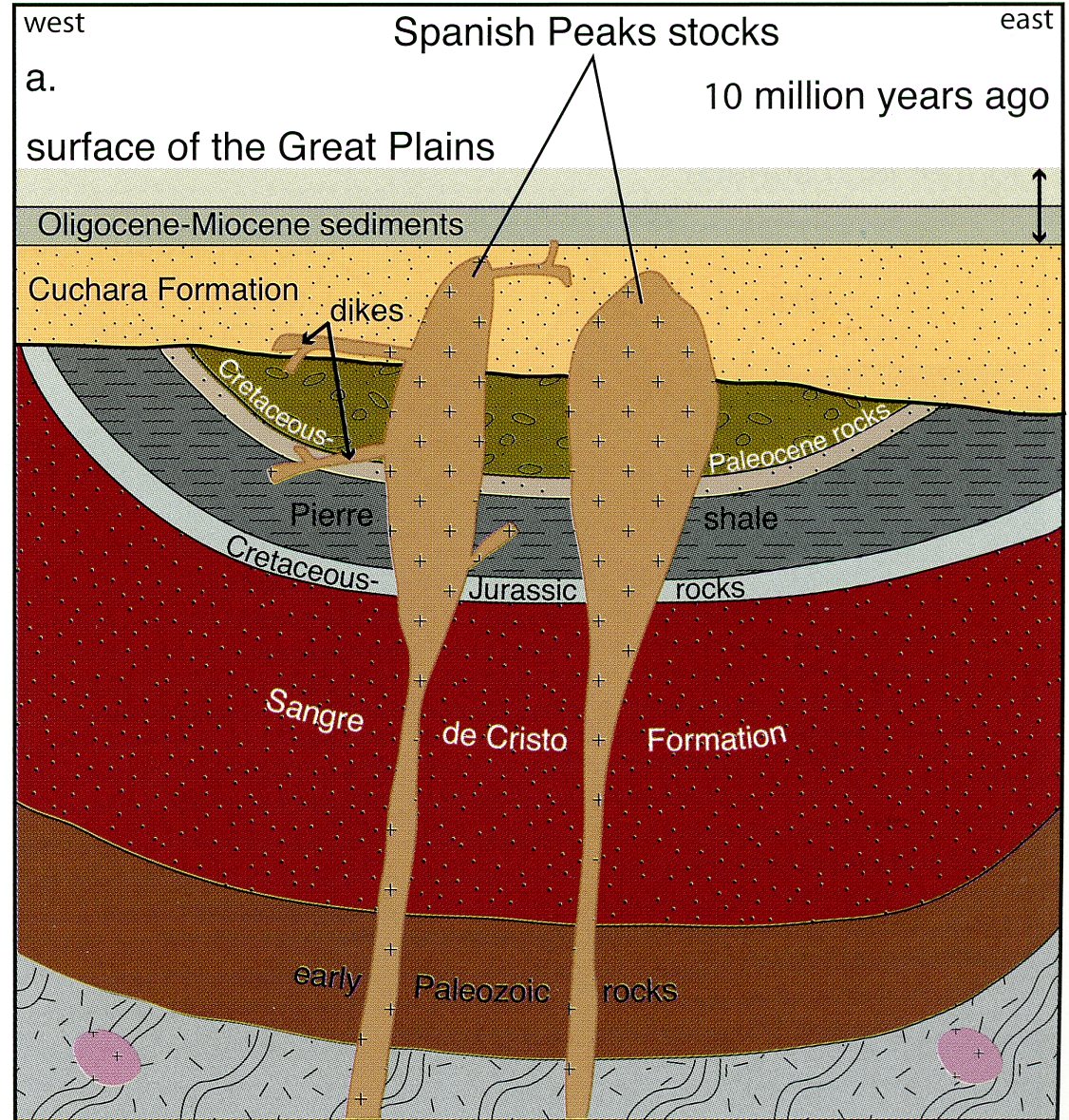
We need to go back further in time to about 65 million years ago when the Rocky Mountains began forming in the first place. Prior to that much of the interior of what we call North America was underwater for a very long time but beginning around 65 million years ago uplift began and the Rocky Mountains began to rise. Its much more complicated but mountain building occurred over time. Forty million years later sediment from our Rocky Mountains was deposited all along the front range and it was these and older sedimentary rocks that magma intruded into some 25 million years ago. Erosion of the mountains continued and by about 10 million years ago they were largely buried and the sedimentary rocks overlying those magma intrusions were even more deeply buried. The drawing above depicts this moment in time.
Beginning about ten million years ago the region began to rise again and those softer sedimentary rock layers began to simultaneously erode (if you want erosion, just raise the mountains!).
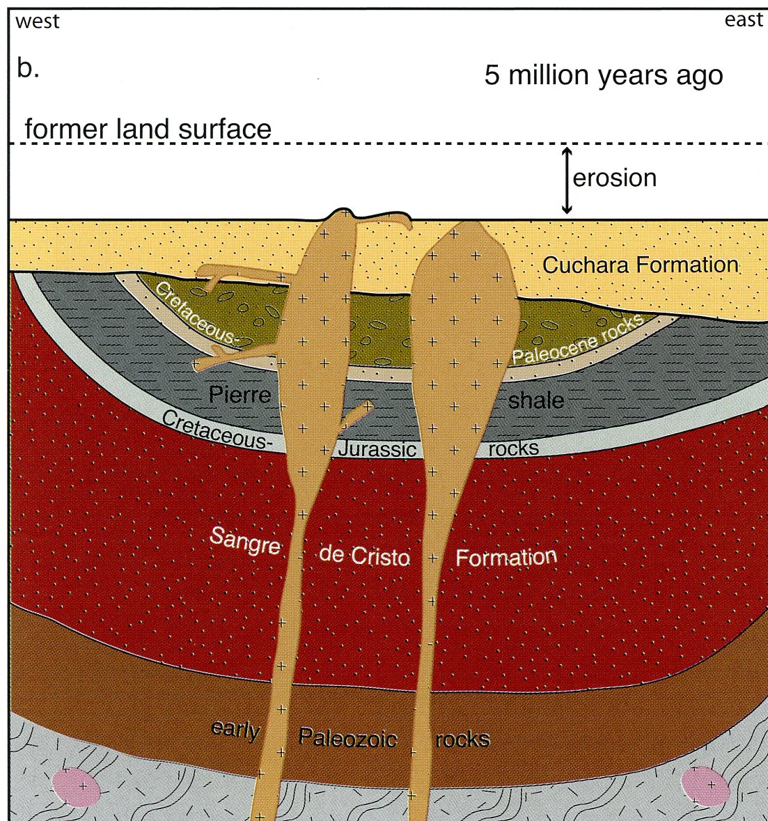
About five million years ago, the tops of the West and East Peak began to peak out above the surface for the first time.
It’s hard to visualize how effective erosion is over a long period of time but geologically a lot can happen in a million years. Think about how many volcanoes and earthquakes you’ve heard about in your lifetime and recognize they represent only a small part of the many geologic changes going on all the time. Another example is that about 200,000 tons of suspended sediment flows out of the Mississippi River into the Gulf of Mexico every day.
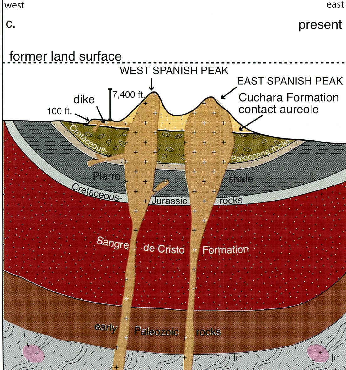
The baked sedimentary rock is depicted as a contact aureole (halo like) on the drawing above.
Over the next five million years the Colorado mountains continued to rise. Simultaneously erosion of overlying sedimentary rocks continued including the relatively soft Cuchara Formation, one of those thick layers of sedimentary rock. The hard-igneous rock that was once molten magma along with the adjacent baked sedimentary were resistant to erosion so they emerged as the spectacular mountains we see today.
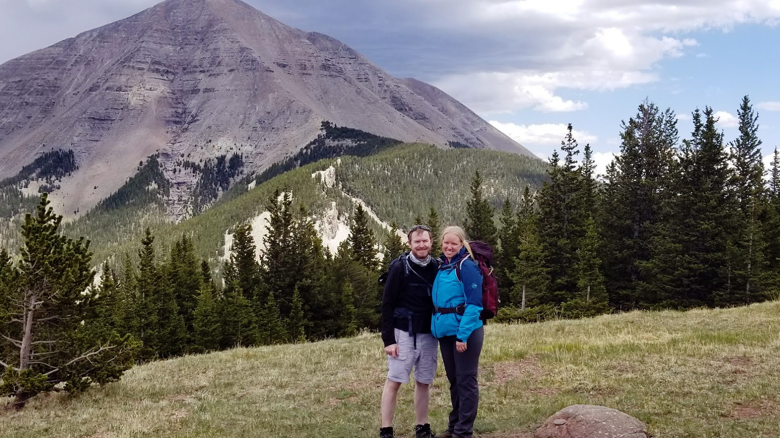
Notice the layered rock on the West Peak. This is the baked Cuchara Formation that became more resistant to erosion. The core of the mountain is igneous rock. Chris Grenard and Emily Kolm in the picture.
++++++
Lover’s Leap
Lover’s Leap is actually an extension of the East Peak Stock. If you make it to the top of that peak someday, the rock will not look a whole lot different than what you can see at Lover’s leap. The picture below is standing on Lover’s Leap and looking south.
The name Lover’s Leap may have a myriad of stories about how the name developed. I found one site describing some of the legends around the Spanish Peaks.
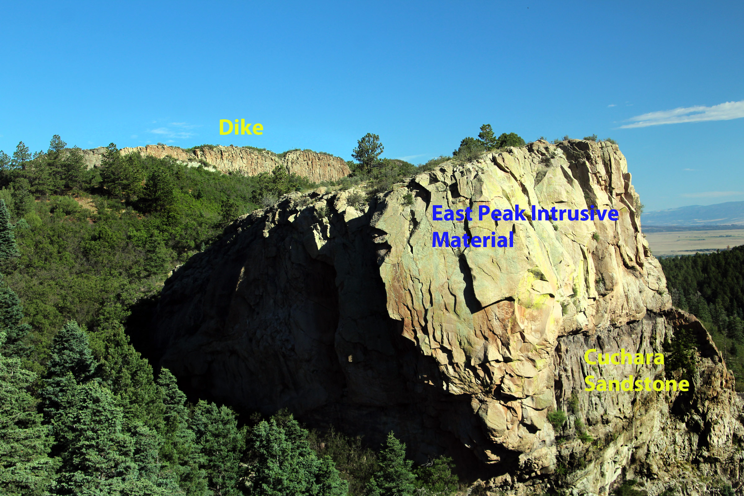
Looking back toward La Veta you can see more of the same rock that makes up Lover’s Leap. One of the great dikes is visible in the background. Notice that the intruded igneous material is lighter in color while the underlying Cuchara Sandstone’s are darker.
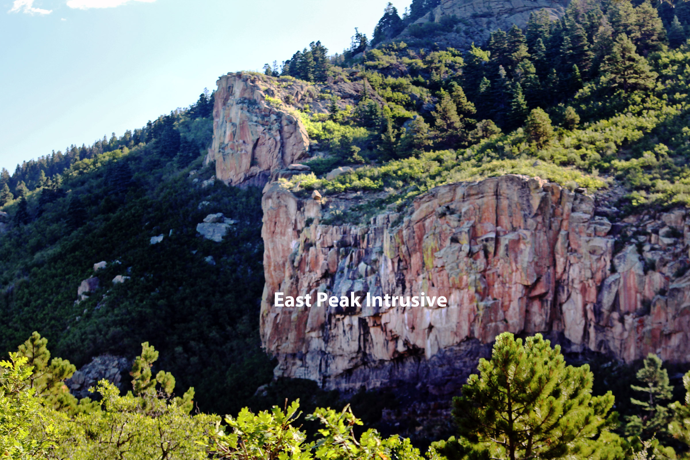
The view above is from Lover’s Leap but looking east at the rock outcrops across Wahatoya canyon. Like Lover’s Leap itself and the outcrop to the south, these rocks also include some of that same material related to the East Peak intrusion.
It may be helpful at this point to look at a broader perspective of the area using google earth. Take a good look at this next picture. It will be followed with the same view but with geology draped on top using the National Geologic Map Database.
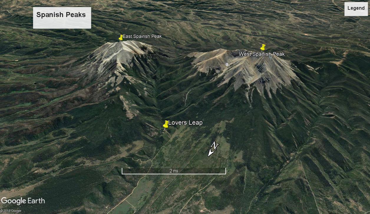
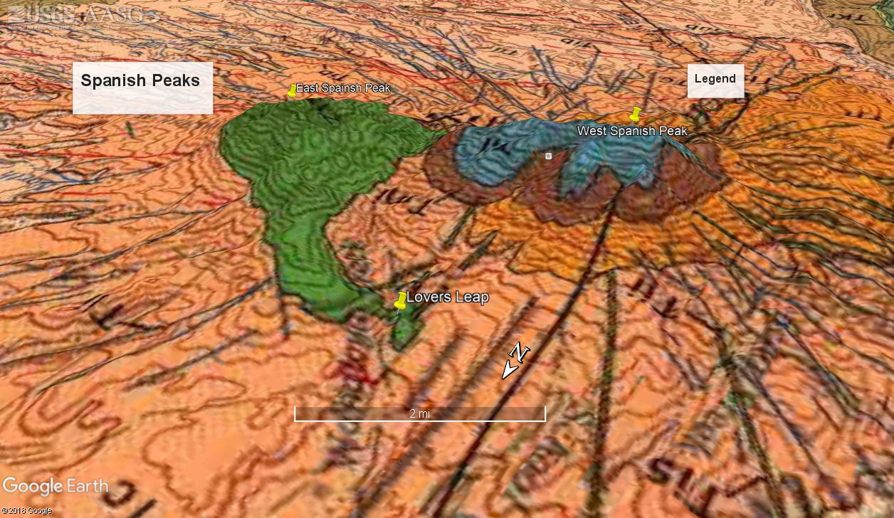
The important thing to note here is the green colored rock. It represents magma that was intruded to become the East Peak but it wasn’t just a single pod, notice the extension that culminates about where Lover’s Leap is (which we just viewed).
++++++
The Cabin Dike (the name of a movie?)
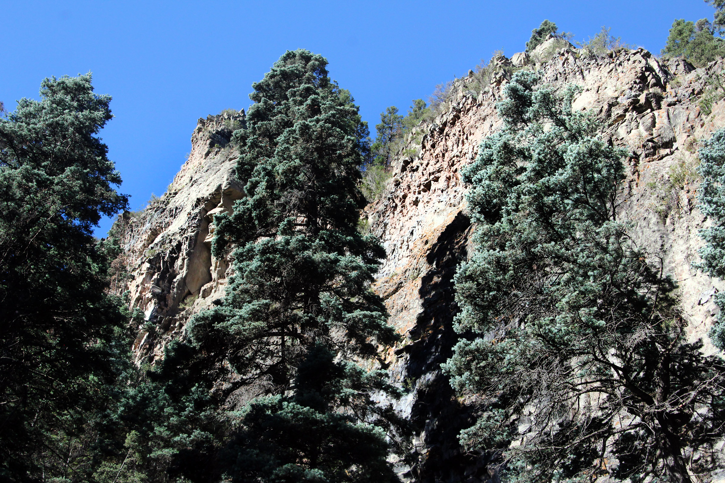
The taller cliff is a relatively prominent point near the Wahatoya Creek just below the Minor Manor cabin. The prominent upper cliff can be seen from a different perspective in the next picture.
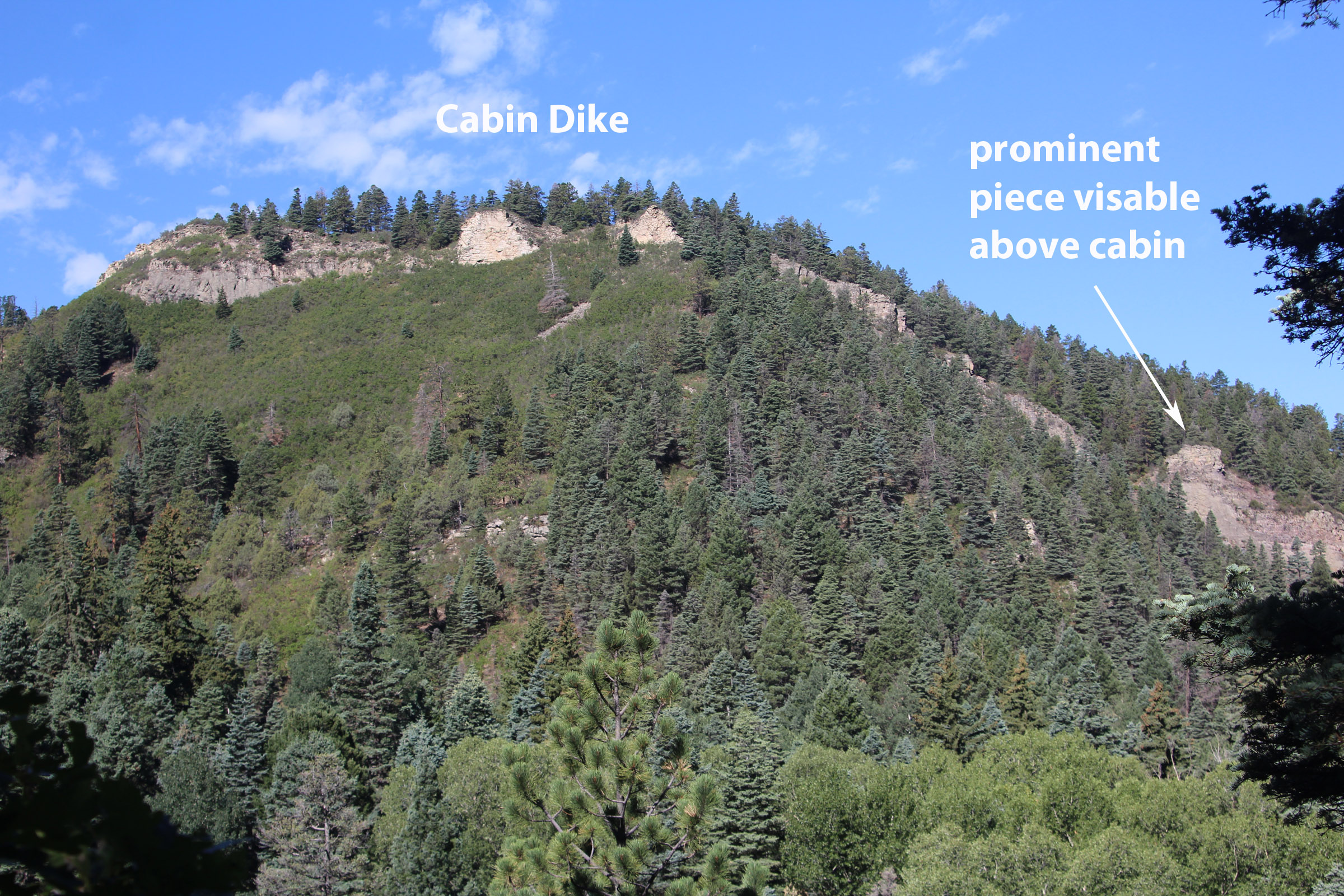
This second view is looking mostly west toward the cabin from an old abandoned logging trail on the hillside to the east across the stream.
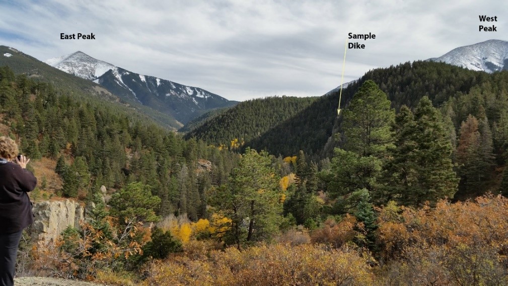
This dike is also visible from Lover’s Leap. It is this dike that was used to provide a donor rock to the PCC Geologic time trail in Canon City. The arrow called “Sample Dike” is pointing to that same prominent cliff. The term “sample dike” indicates that it is the one used for the donation material to the geologic time trail. There is one additional place you can see this dike and that is walking on top of it which is possible if you drive or walk up the Bulls Eye Mine Road (take off point a few hundred feet west of Lover’s Leap).
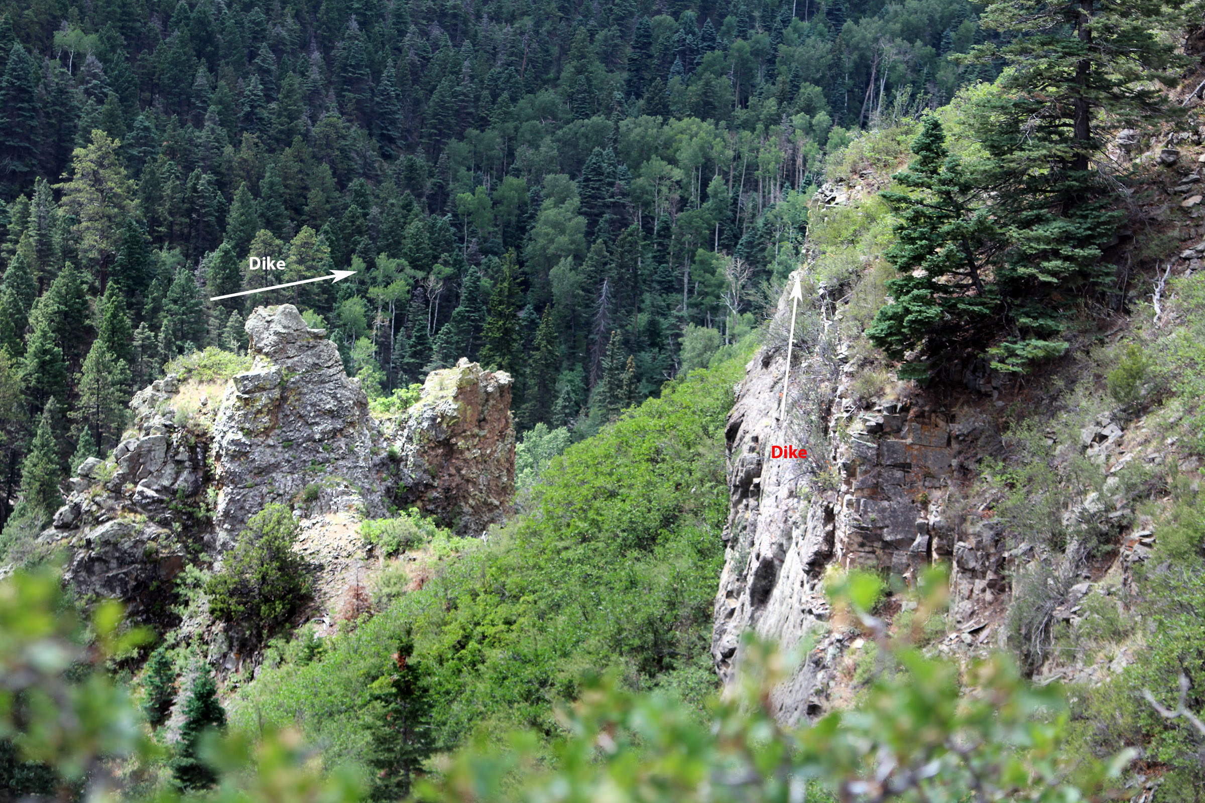
This picture above is the same dike but viewed a way up the Bulls Eye Road and walking over to the edge where you can look down into Wahatoya Canyon. There is one place you can see both the cabin dike (red print) and another dike (white print). You can also see some cabins, one fairly prominently. Later when we were back down in Wahatoya Canyon we located the same cabin and then looked up to verify where we were previously.
One thing we notice when looking at this dike in different locations is that overall it had a similar, but not exactly the same, appearance wherever you see it. It was usually fine grained and a fairly light tan color.
++++++
A Geological Time Trail donation
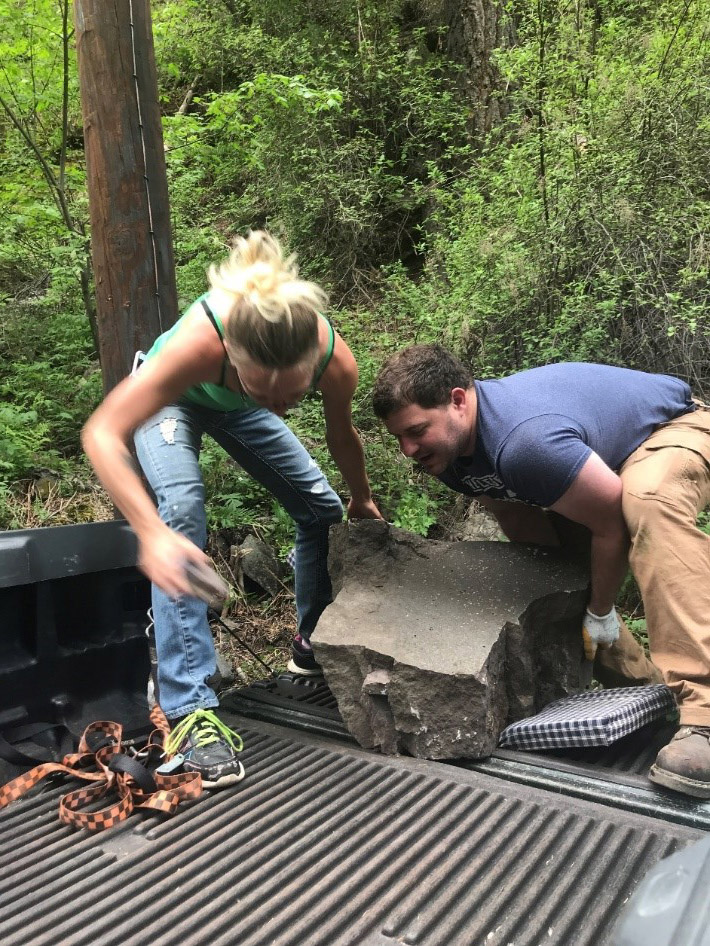
On May 27, 2018 Jon Paul Grenard and his able-bodied assistant Emily Chadwick, backed a small pickup next to the lodged rock and pushed it into the back. I visually inspected the dike and this particular rock and confirmed it was the same material. The approximate location the rock was found in was 37°25’9.52” N and 104°58’27.59″W. The particular small boulder was selected because it had broken off the main dike, rolled down hill and lodged up against a power pole.
Based on the Johnson Report, the West Spanish Peak is made up mainly of one of the varieties of a relatively fine grained igneous rocks. For our simplified purposes here, they typically a medium to coarse grained igneous rocks. The Lindsey Report describes the rock compositions for the West Spanish Peak radial dikes as monzonite and syenite porphyries. In general, they described the textures as relatively fine grained (crystalline to glassy) with a lot of ground mass. They also describe the textures of the rocks of the Spanish Peaks region are holocrystalline phaneritic (crystalline) and porphyritic-aphanitic (some crystalline texture to little crystalline or glassy texture) with as much as 70 percent of the rock composed of groundmass or an aphanitic texture[1]. Maybe just think of the dike rock as a very fine grained, light colored, igneous rock with a few small crystals in it (porphyritic). It’s a bit gray on this specimen due to weathering.
A reasonable estimate of the age of the dike rock based on an age dating diagram from the Penn and Lindsey report used for the time trail is 22 ½ million years old [2].
A special note on the Geologic Time Trail is that we had some extensive damage on July 21, 2018 due to flooding that was result of several inches of rain falling in a very short period of time. A restoration plan is getting underway ASAP. Canon City had a lot of damage to homes also as a result.
[1] Penn and Lindsey, Tertiary Igneous Rocks and Laramide Structure and Stratigraphy of the Spanish Peaks Region, South-Central Colorado.
[2] Penn and Lindsey.
++++++
The Cuchara Formation (Sandstone)
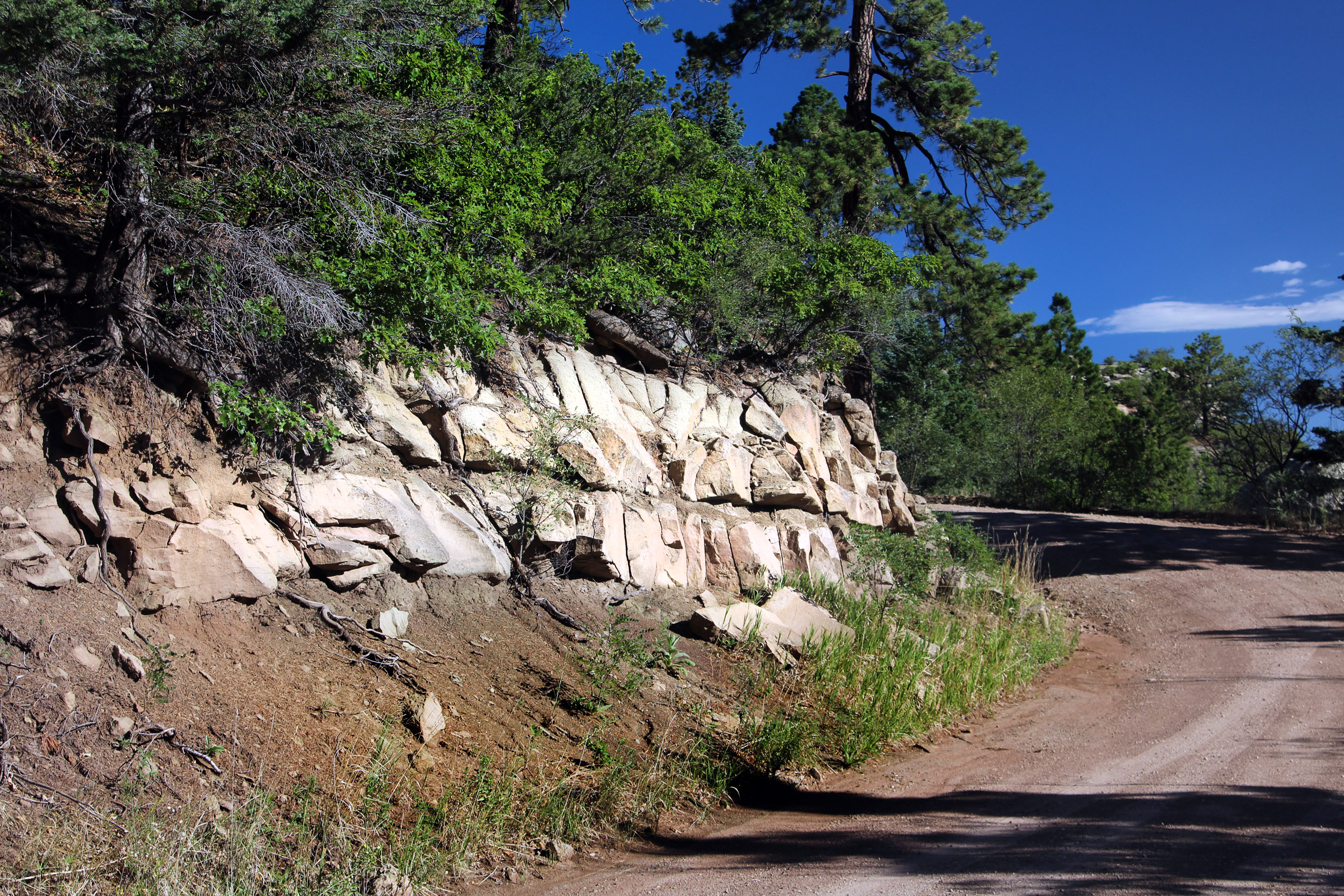
We would be remiss not to mention the rock that was intruded by the Spanish Peaks some 25 million years ago. Some of this sedimentary rock included intruded the Cuchara Formation which is fairly prominent in the La Veta area as relatively flat lying cliffs. The formation is several thousand feet thick representing sediment that was washed down off from the Culebra Range (part of the Sangre de Christo mountains) well before the magma intruded the area. This sediment accumulated as alluvial fans and river deposits adjacent to the mountain range. These are mostly fine grained but some layers have pebbles and larger material. The parts of this formation close to where the magma was intruded are hard while most of it remained relatively soft. This view of the Cuchara Formation is just down the road from Lover’s Leap and a careful observation will reveal soft red mudstone visible below the sandstone.
+++++++
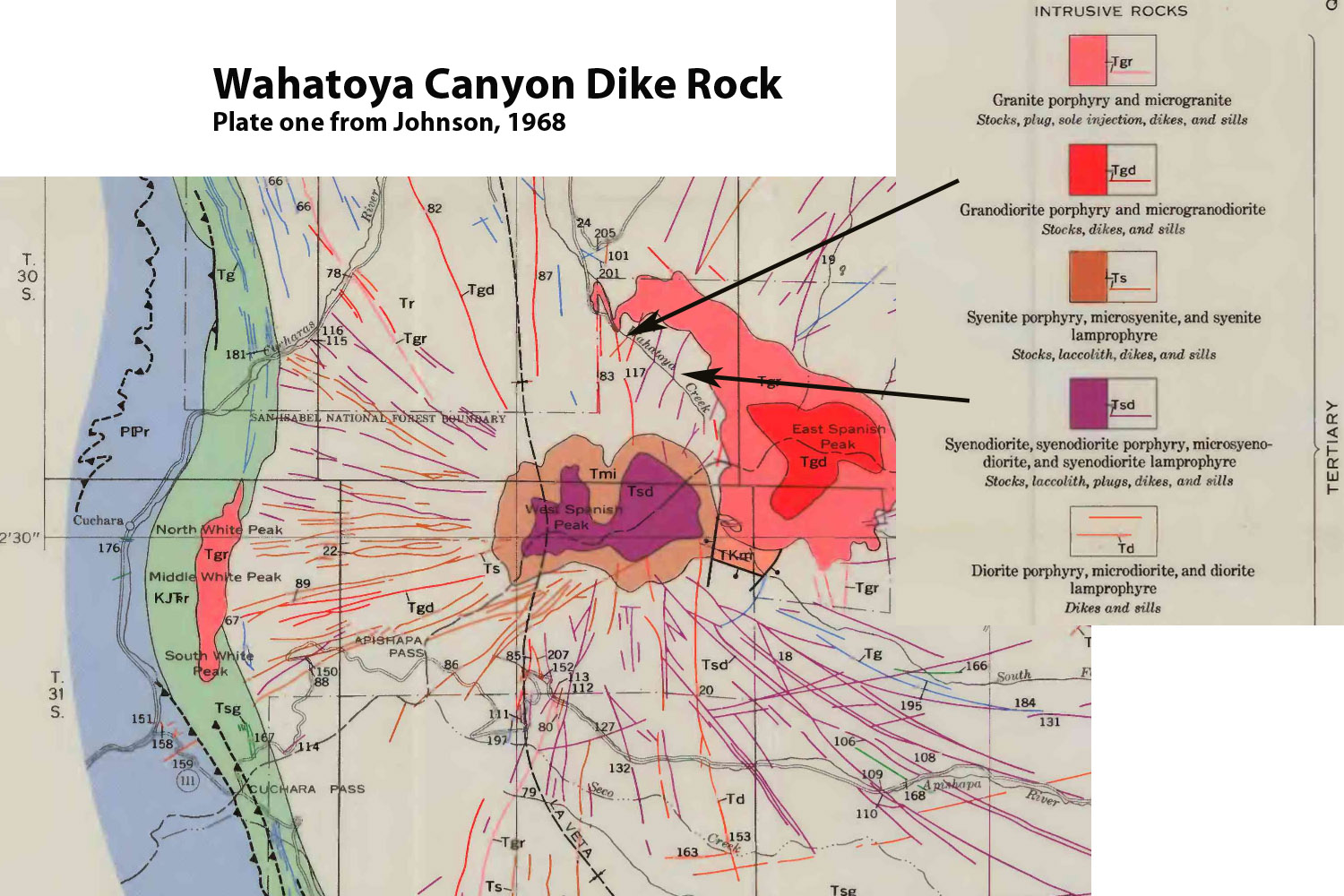
Map of igneous intrusions in the area.
References:
Abbott, Lon, and Terri Cook. Geology Underfoot along Colorado’s Front Range, 2012.
Johnson, Ross B. Geology of the Igneous Rocks of the Spanish Peaks Region, Colorado. Washington: U.S. Govt. Print. Off., 1968.
Penn, Brian S, and David A Lindsey. Tertiary Igneous Rocks and Laramide Structure and Stratigraphy of the Spanish Peaks Region, South-Central Colorado: Road Log and Descriptions from Walsenberg to La Veta (First Day) and La Veta to Aguilar (Second Day). Denver, Colo.: Colorado Geological Survey, Dept. of Natural Resources, 1996.
Excellent and informative! Mr. Minor is a very talented guy. We love the canyon and the Wahatoya area.
Dennis and Beverly Hill
“The Hillton”
Thank you so much for passing on this fascinating
Information. It is too far beyond me to really comprehend, but I am challenged to try. This area that we love is truly awesome!
Anita Akin Lawrence
Harris, Akin, Lawrence Cabin
I like what you’ve done here.
I showed in a poster I presented at GSA a couple of years ago that all of the magmas in the Spanish Peaks were derived from partial melting in the lower crust (or deeper if you consider the lamprophyres are derived from the aesthenosphere or upper mantle.) I used a technique involving partitioning of compatible and incompatible elements associated with partial melting vs fractional crystallization. For this particular case, I used the lanthanide series (Rare Earth Elements) because of their unique properties and the notion of lanthanide contraction which makes the lighter REE compatible and the heavy REE incompatible. It all has to do with ionic radii.
Assuming all of the magmas were derived by partial melting of upper mantle and lower crustal rocks, each composition you see came from a different depth. The silica poor rocks, i.e, basalts and lamprophyres are probably from the aesthenosphere or lithospheric mantle region. We know from experimental petrology that granite is restricted to depths of about 35 Km and shallower. The monzonites and syenites were derived from depths > 35 km.
West Spanish Peak (WSP) is older and composed of a qtz monzonite, suggesting that it came up from > 35 km. Interestingly there are numerous dikes that cross-cut the summit of WSP. Also, there are numerous basalt sills found above treeline on the west side of WSP. Johnson (1968) noted the metamorphic aureole attached to the outer portions of WSP. You can see this from La Veta as horizontal layers above treeline (and your picture above.) WSP acted like a bullet penetrating glass when it was emplaced creating radial fractures that were later expanded and filled by hydrofracting magmas of the radial dikes. We don’t see any place where a dike actually contacts the WSP stock, so we assume they came later (this was corraborated by Ar-Ar dating.) This was modeled by Otto Muller, a structural geologist) as a pressurized cylinder, surrounded by an infinite elastic plane with a rigid boundary to the west (Sangre de Cristo mtns.)
Regarding East and West Spanish Peaks. As I said, West Spanish Peak is a qtz. monzonite porphyry; East Spanish Peak is granite porphyry with a core of granodiorite porphyry. Both Lover’s Leap and Devil’s Stairsteps are granodiorite porphyry suggesting that the East Spanish Peak stock had fingers that extended outwards. I suggested previously that the larger portion of East Spanish Peak consists of granodiorite porphyry and the granite porphyry we see at the surface is part of the upper portion of the original magma chamber. This is consistent with the idea that granodiorite magma quickly evolved to more siliceous compositions as it cooled rapidly when it came into contact with the surrounding bedrock.
I think what is missing is the context of the Spanish Peaks. Silver Mtn. is much older than the Spanish Peaks (36 Ma – early Oligocene) and corresponds with the beginning of what’s called the Ignimbrite Flareup. This was a widespread series of volcanic eruptions during Oligocene time that resulted in the San Juan Mts., 39-Mile volcanic field, Silvercliffe and Rosita Volcanic fields. Steven (1975) speculated that these were all part of the Southern Rocky Mountain Volcanic field. The San Luis valley (or Rio Grande Rift) barely reached the Colorado – New Mexico border 30 Ma, and most of these volcanic fields mentioned were probably continuous at that time. Even the Wet Mountain Valley (Huerfano Park) didn’t exist 30 Ma. It is truly interesting that the igneous rocks of the Spanish Peaks actually temporally bracket the time of the Ignimbrite Flareup.
For more details, see my website below. If you’d like to speak with me personally, I am scheduled to give talks on the Igneous Petrology of the Spanish Peaks at Lathrop State Park this summer. Unfortunately, I found out today (5/27/2020) that the first talk which was scheduled for next weekend has been cancelled due the COVID-19. I have another talk scheduled the weekend of Ft. Franciso Days in the end of July in La Veta.
The website I was referring to in my previous comment is: http://www.spanishpeakscolorado.com. I put up the website in 1995.